
DOWNLOAD THE APP


Customer Services
Copyright © 2025 Desertcart Holdings Limited
DOWNLOAD THE APP

🚀 Survey Smarter, Not Harder — Precision Meets Power in Your Hands
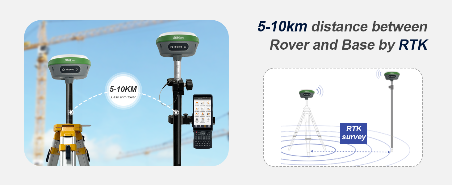
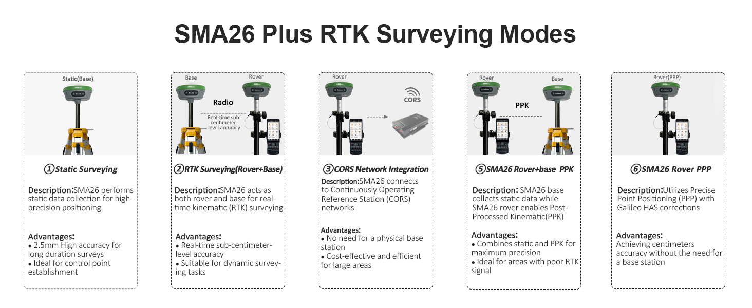
The SMA26 RTK GNSS GPS Surveying Equipment delivers industry-leading 0.5cm accuracy using 1408 multi-constellation channels, NOAA certification, and advanced IMU tilt measurement. With up to 10km UHF range, 2-day battery life, and versatile connectivity options including Wi-Fi, Bluetooth, USB-C, and CORS network support, it’s engineered for professional-grade surveying across diverse environments. The handheld collector comes pre-loaded with permanently valid RTK software, ensuring seamless, reliable data collection and processing for topographic, engineering, agricultural, and mining applications.


| ASIN | B0BYCR3VQQ |
| Best Sellers Rank | #6,479 in Sporting Goods ( See Top 100 in Sporting Goods ) #3 in Marine Electronics |
| Department | Men's |
| Item model number | SMA26 RTK |
| Manufacturer | SMAJAYU |
| Product Dimensions | 13.97 x 13.97 x 8.64 cm; 9 kg |
A**O
MUY BUEN PRODUCTO YA LLEVO MAS DE DOS MESE CON EL, EL GNSS R26 - V2 ES MUY BUEN PRODUCTO YA QUE TIENE CALIBRACION DE LA NOAA PARA PROCESOS PPP ARROJA MUY BUENOS RESULTADOS AUN EN CIUDAD Y A CIELO ABIERTO MUCHO MEJORES POR EL METODO ESTATICO. EN RTK LA UNIDAD DE MODULO INERCIAL ES DE GRAN AYUDA YA QUE HAY PUNTOS DIFICILES Y TE AYUDA MUY BIEN. EN RESUMEN UN EQUIPO QUE VALE MUCHO LA PENA ADQUIRIRLO.
E**Z
I'd like to start by saying though I've used and tested various brands of GPS equipment. I purchased this one and immediately was not disappointed. After about a month of tests, I've found this product to be reliable and consistently accurate. The GPS receivers will definitely run for more than a day with just one charge. The USB-C charging cables provided are great, especially compared to working with other major brands that require a special charging base for charging the batteries. As a test I went almost 5 miles away from my base and still had reception. The IMU is accurate as well. The data collector and software has been great as well. The software is pre-installed and runs pretty smooth. It allows you to plug in a SIM card for those that enjoy using NTRIP services for their surveys. Long story short, the unit and software is a great value for your money. Their customer service is amazing. Just send them an email and they will respond in under 24 hours with the correct and detailed information. I don't normally write reviews for anything, but this equipment is definitely worth purchasing and trying out, because you will not be disappointed.
S**Y
This is a amazing, sophisticated piece of equipment. i purchased to find my property stakes spread all over 50 acres of trees. Like a needle in a haystack. They have the best support i ever come across. I knew nothing of how to work this equipment but i feel their support turned me into a professional. I found all my stakes and saved over 100,000$ Our local land survey charge 5,000$ an acre on open land more with trees. I highly recommend this to anyone, well worth the money, Thank you SMAJAYU
D**.
The learning curve on this was long, but it works like advertised. There are cons - no instruction manual; the data collector screen is difficult to see in bright sunlight; the available YouTube videos are not all that helpful - but the pros outweigh them. The units work well and provide real-time centimeter accuracy. The range is advertised as up to 1km, and I realize that is in the best of circumstances, but we are having no problem up to one mile in the hills and heavy foliage of the Ozarks. I suspect we can get even better range. The couple of times I have contacted the sellers, they have responded quickly. This is a good product at a fantastic price.
A**O
Muy buen equipo GNSS, cuenta con muy buena precisión, compactos, graban rinex, son completos y lo que me gustó más fue su colectora, la medición de inclinación y su forma de replantear con camara con la colectora.
Trustpilot
2 weeks ago
2 days ago