Some deliveries may take a little longer than usual due to regional shipping conditions.

DOWNLOAD THE APP


Customer Services
Copyright © 2025 Desertcart Holdings Limited
DOWNLOAD THE APP
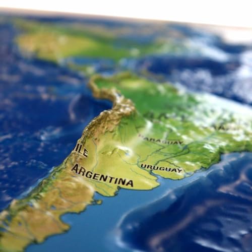

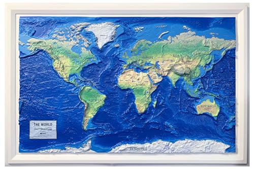
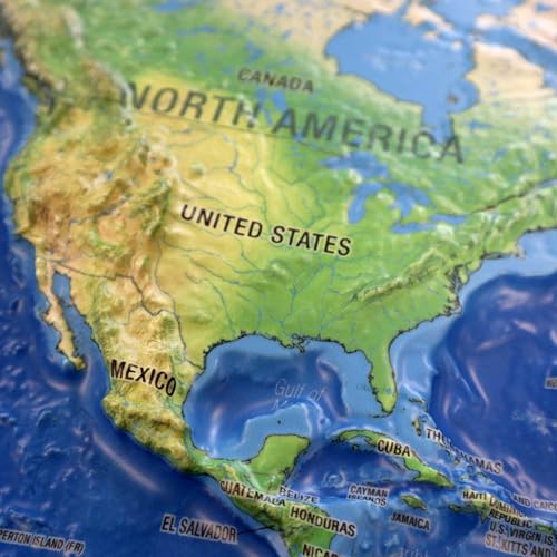


World Ranger 3D Map by Hubbard Scientific | A True Raised Relief Map - You Can Feel the Terrain | Vacuum-formed Molded Map | 36'' x 24'' | Detailed Topography : desertcart.co.uk: Stationery & Office Supplies Review: This map is beautifully made and very high quality. Review: A family member was trying to understand the location of Egypt — other maps had so much information, including color coding to help one see national boundaries, that it was hard to get oriented. This map shows country boundaries, but the information is primarily about the earth itself — the topography, vegetation, and waters. As a result, one instantly, viscerally, gets a sense of the relations of things — of how dramatic the Himalayas are, and the mountainous west coast of South America. Right away we could see Egypt’s relationship to Africa, the Mediterranean and Europe. It takes more than one kind of map to see an area, but this is an excellent map for starting with the big picture. It’s well-made, too. Just love it!


| ASIN | B0CLM8SQ7R |
| Customer reviews | 4.0 4.0 out of 5 stars (23) |
| Dimensions | 91.44 x 60.96 x 0.25 cm |
| Item weight | 249 g |
| Publication date | 1 Jan. 2023 |
| Publisher | HUBBARD SCIENTIFIC |
H**H
This map is beautifully made and very high quality.
K**A
A family member was trying to understand the location of Egypt — other maps had so much information, including color coding to help one see national boundaries, that it was hard to get oriented. This map shows country boundaries, but the information is primarily about the earth itself — the topography, vegetation, and waters. As a result, one instantly, viscerally, gets a sense of the relations of things — of how dramatic the Himalayas are, and the mountainous west coast of South America. Right away we could see Egypt’s relationship to Africa, the Mediterranean and Europe. It takes more than one kind of map to see an area, but this is an excellent map for starting with the big picture. It’s well-made, too. Just love it!
Y**A
I’m going to start by saying that is way too expensive for the quality and it also needs to be in a better package, so it I’m going to start by saying that is way too expensive for the quality and it also needs to be in a better package, so it doesn’t ben. I think it should be more like $ 50 or less. I’m going to keep it since I got it for my son’s birthday.
W**E
I ordered the map for my high school science classroom. It arrived with a small split at a corner - not a huge problem but for the money it should be unblemished - and the print was off from the relief by about 1/4 inch, so there is a distortion between where submerged and non-submerged landforms are. But the biggest problem by far is that the scale of the relief elevations is exaggerated too much to be useful in a classroom. For example, if you apply the distance scale to elevation, the Himalayas rise about 500 miles above sea level. It could be there was an error made with the manufacture of just this one map and also the description did not state explicitly that the elevation is to scale, so I was taking a chance. This could absolutely be useful in a classroom setting for younger students to give a general idea of landforms, but not for secondary level.
I**1
The map is lightweight and has excellent detail. Our grandson is into geography and he loves the map. We were even able to use the map to discuss how the continents moved apart because there is good detail. The product arrived ahead of schedule, well in time for Christmas.
Trustpilot
2 weeks ago
4 days ago