We remain fully operational. Our teams are working around the clock to ensure your deliveries continue safely.

DOWNLOAD THE APP


Copyright © 2025 Desertcart Holdings Limited
DOWNLOAD THE APP

Buy anything from 5,000+ international stores. One checkout price. No surprise fees. Join 2M+ shoppers on Desertcart.
Desertcart purchases this item on your behalf and handles shipping, customs, and support to South Africa.
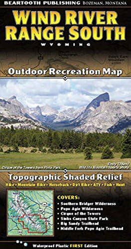
Beartooth PublishingWind River Mountains Topographic Map - Southern Half
| Item Package Dimensions L x W x H | 7 x 4.2 x 0.4 inches |
| Package Weight | 0.29 Kilograms |
| Item Dimensions LxWxH | 0.2 x 8 x 4.2 inches |
| Brand Name | Beartooth Publishing |
| Color | full color |
| Part Number | ABCD |
C**.
Great folding map.
It unfolds well, and folds back into place like a champion of maps.
G**M
got me exactly where i wanted to be
Accurate and durable... the map was easy to read and looked new after 9 days in the Winds. Was also compact and easy to close.
G**E
Best map of the area!
Best map of the area!
M**.
What was annoying is that
The map has a lot of details, although not all trails are marked. I think it has as much detail as any Trails Illustrated product, though. What was annoying is that, after day 3 of a 5 day trip, I concluded, based on a Gaia Topo Maps app on my phone, that either the GPS tracking in my phone was off, or the mileages for trail sections marked on this map are consistently off by about 20%, being approximately 80% in value of what the actual distance turned out to be. I haven't compared these numbers to any of the guidebooks printed for the area I was in.
A**R
Four Stars
nice map
U**N
... guess the map is durable but not at all like I hoped it would be
I guess the map is durable but not at all like I hoped it would be. You can get the same map for free at any ranger station. My Foghorn camping book is much more informative for about the same money. I am very disappointed.
Trustpilot
2 days ago
1 month ago
3 weeks ago
1 month ago