

๐ Your Adventure Awaits!
The Magellan Meridian Color Handheld GPS Navigator is a robust and reliable device featuring a full-color display, WAAS technology for superior accuracy, and ample memory for mapping North America. Its durable, waterproof design and long battery life make it the perfect companion for outdoor enthusiasts.
| ASIN | B00007KVHO |
| Additional Features | Bearing, CTS (Course to Steer), Distance, Electronic compass, Elevation, Heading, NorthFinder, Time/date, VMG (Velocity Made Good), XTE (Cross Track Error) |
| Are Batteries Included | No |
| Battery Average Life | 13 Hours |
| Best Sellers Rank | #397,777 in Electronics ( See Top 100 in Electronics ) #424 in Handheld GPS Units |
| Brand | Magellan |
| Built-In Media | USB interface with cable, Built-in antenna |
| Compatible with Vehicle Type | Car, SUV, Truck |
| Connectivity Technology | Serial |
| Control Method | Voice |
| Customer Reviews | 4.2 out of 5 stars 26 Reviews |
| Display Type | LCD |
| Global Trade Identification Number | 00763357104141 |
| Human-Interface Input | Keyboard |
| Item Dimensions L x W x H | 2.9"L x 1.2"W x 6.5"H |
| Item Weight | 1.3 Pounds |
| Manufacturer | Magellan Navigation |
| Map Types | North America |
| Memory Storage Capacity | 16 MB |
| Mfr Part Number | 980598-18 |
| Model Name | Magellan Meridian Color |
| Model Number | 980598-18 |
| Mounting Type | Handheld |
| Resolution | 120 x 160 |
| Screen Size | 2.2 Inches |
| Special Feature | Bearing, CTS (Course to Steer), Distance, Electronic compass, Elevation, Heading, NorthFinder, Time/date, VMG (Velocity Made Good), XTE (Cross Track Error) Special Feature Bearing, CTS (Course to Steer), Distance, Electronic compass, Elevation, Heading, NorthFinder, Time/date, VMG (Velocity Made Good), XTE (Cross Track Error) See more |
| Sport Type | Running |
| Supported Satellite Navigation System | GPS |
| UPC | 763357104141 |
| Unit Count | 1.0 Count |
| Vehicle Service Type | Car, SUV, Truck |
C**E
Magellan Meridian Color Handheld GPS Navigator (16 MB)
The GPS Magellan Meridian Color Handheld GPS was shipped promptly, and works as advertized. Its color screens are crisp, easy to read and the GPS is very user-friendly. The instructions that came with the GPS are helpful and well organized.
A**R
Great gps
I have had this same unit since about 2003. If finally died on me, I was ecstatic to find the same unit on Amazon, replaceable double AA batteries, screen is smallish but big enough to see and clear, lots of great features, tracking, interfacing with paper maps ( gotta purchase the extra accessories). I will definitely be purchasing this unitโฆsoonest!!
O**R
Meridian COLOR vs. PLATINUM
Display: The COLOR has no-light/dim/bright, as does the PLATINUM. But the COLOR it is only usable with bright lights in daylight and dim during nighttime, with no lights you don't see anything. The Platinum w/o light has still an acceptable display and runs for about 8 hrs, the COLOR on bright runs slightly over 4 hrs (1.850 mAh). Functionality: The colored display is very helpful together with Topo Send. You can easily distinguish between different graphics by the color; like arroyos and dirt-roads, specially marked arreas and lakes, etc. What is missing on the COLOR compared to the PLATINUM is the baro, thermo and the build in electronic compass (not gps dependent). I thermo and baro I found fun to play around with but never really found a serious application. The compass needs constant alignment and is often considerably off. For all those applications there is way better stuff out there. The COLOR has the better software wich might be due to the fact that I downloaded the latest software to it (v. 5.12). After v. 5.xx there is supposed to be a street navigation function to it, which I haven't found yet- maybe only works with MapStreets. Durability: As I pointed out in my earlier review on the PLATINUM this unit is extremely rugged and highly reliable in the field. I figure so will be the COLOR. Deficiencies: The backtrack function is higly deficient. When you wanna walk back you have to hit every single point this function created on the way back. Often you don't do that because you do a shortcut. Neither one of those units does allow you to bypass one single point and from now it desperatly points back to the one point you might have missed by a couple of feets. Map-Download: has certain limitations which are discussed in some other reviews on this side. Even with the latest software I was only able to download 3 regions to one map, but 4 maps alltogether with a total of 120mb over my PDA (Card-Reader might be even better) by doing the following: 1. Without connecting your Meridian to a PC, begin the map Upload process (click Regions; then Upload to GPS). 2. When the map data conversion process is done, MapSend will display a message that it cannot find your GPS receiver to perform the download. 3. Stop the process here by selecting "Cancel". 4. Using Windows Explorer, go to Program Files/Magellan/MapSend/Export and locate the file called "maps.img". 5. Copy this file to the SD card using USB card reader. Do not create any folders within the SD card where you place this file. Your Meridian will always looks at the top, or "Root" level within the card. 6. Rename the file "XXXXXX.img" - Example (SO California.img). 7. Remove the card and place it in your Meridian. You can use your Meridian as you would normally from here. (If you have at least software version 3.12 loaded on your Meridian, you will be able to select a map image to use from the Card Utilities menu - Press MENU to find Card Utilities) Verdict: I do recommend both units, but do personally prefer the COLOR for its more consise display even considering the extra functions on the PLATINUM. Because of certain flaws in the software I give both a 4 out of 5.
M**K
What a Bringdown
After losing an older Meridian Marine, I decided to make use of my software and buy this unit since I LOVED the previous model for a few years. When I received this model it seemed to be working fine when I initialized it. It came with antique version 4.02 firmware, marked from 2002. The unit refused all my software (specifically uploading REGIONS off the Topo, Nav, and World Basemap discs) until I upgraded the firmware to anything above v.5. When I tried to install v5.34 from the CD or v. 5.40 which I downloaded, it kept freezing and wouldn't accept the firmware. I then called tech support (NOT open 24/7!...just California time 6am-5:30pm, weekdays). I spent a total of 3 hours on hold during my 4 phonecalls!!!! The obviously outsourced "tech experts" (trained British accents, probably in Pakistan) then repeatedly walked me thru the same steps to fix the problem as though they were encountering them for the first time! I even got the same guy twice. One said I'd get a callback the next day at 7:30 PM New York time. It never happened. After giving up, one of them transferred me to a "senior-technician" who did no better. After even she gave up, she said she had to look up something and would call me back within 30 minutes. Guess what....It never happened (again)! No matter how great the unit might be, I will never do business again with a sleazy excuse for a professional Company named Magellan (Thales Communications). Even the "worldwide basemap", which I bought the unit for, only gave me an OUTLINE of Panama...no roads, no nothing!! In all my 58 years, with all my toys (boats/radar/stereos,medical electronics, cameras, etc,etc, etc), this is the single WORST response I've ever had to asking for HELP, especially on a BRAND-NEW product!
N**R
Five Stars
Excellent. Product was like new.
M**L
Magellan Color is Tops
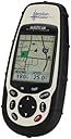
This is the 2nd Magellan GPS I own, I also have a 315 series GPS. I had prior experience with GPS's, (my 315 and military GPS's) so it was really easy for me to get comfortable with this unit. Turning on the unit, the first thing I noticed was the VIBRANT color display, which was the main reason I bought the unit. I bought a Sport Trac, but really wanted the color screen. I think there are 7 screen on this unit. Satellite position, the map screen, compass, large data display, speed, position and the road screen. Each screen has data fields that are totally customizable, with no less than 12 different data displays. This unit does just about anything dealing with navigation, map datum, unit of measure, time format, mils versus degrees, it does projection based on time, contour elevation, everything. I bought the software containing elevation, and when maps are downloaded it shows the contour interval, I want to buy the turn-by-turn software, but it is kinda pricey. The software is easy to use, the hard part is getting past the limitations. I used a SD card reader to put the images directly into the card, but I also hook it to the computer with a USB to Serial adapter, as you can download your track history onto your computer and replay your entire trip back in varying levels of speed. Really there is so much this does it is hard to remember everything. Some of the things i don't much like are the fact you have to take the battery cover off and take the batteries out to get to the card, I use a 512mb card, and it is way more than enough space for whatever I need to put on. You can put all your way points in the way the maps are put in, but I have not delved into that to much. Another thing is when it is first powered up, you have to watch the screen for a disclaimer about using at your own risk, then have to hit enter to procede, if you don't hit enter within maybe 20 seconds it powers off. Well, I have used it alot, and I love it, the only thing better would be a Roadmate, but you get about the same thing at 1/3 the cost. I would highly recommend this unit to a beginner or advanced user alike.
L**N
Serious Navigation Tool
This is the best hand-held GPS. It is upgradable with new maps which you won't find on some others. The color screen is easy to read, bright and dims easily to save power. All in all, it fits the bill for the serious traveler. This powerful tool actually asists you in navigating your own route, far prefereable for my liking than others which tell you which way to go. I like to make choices, and I have experienced more direct routes and discovered many roads and foot routes less traveled all over the US and Europe with the assistance of this wonderful device. I have discovered marvelous places with my Magellan -- places only the locals know. I have used my Magellan Meridian Color GPS for three years, and I can't imagine how it can be improved upon. I consider it indespensible for traveling. Works great in the car, and then you can take it with you on foot, train or bus. If you apply yourself to learning how to use this device it will increase your satisfaction in traveling and knowledge of your surroundings.
K**S
Feature rich, quality unit, color screen is a miss
I have used a downloaded mapping GPS since 1998 and use it extensively. The pluses on the Meridian Color are: SD memory cards - I can finally carry the maps I need, uses only 2 AA batteries, well built and waterproof, searchable addresses, extensive points of interest, maps of Canada and parts of Europe, programmable navigation menus. I use a USB 2.0 SD card reader and a 256MB SD card and can quickly download 64 MB maps. Multiple maps can be stored on the SD card up to your storage limit. Using a card reader the map creation and storage process is done in a couple of minutes. The misses: the color screen is not a helpful as I expected, in daytime use the screen is very dark and hard to see even with the backlight on draining the batteries quickly, still needs better waypoint management, the Topo maps are not a useful as I expected. Good unit, but I would probably have been better off with the Meridian Gold due to the Color unit's hard to see screen.
Trustpilot
2 days ago
2 weeks ago